By Gisele Galoustian, FAU News Desk
Peatlands – a type of wetland found around the globe at all latitudes, from the Arctic to the tropics – are important ecosystems that store vast amounts of carbon. In fact, peatlands hold about one-third of the world’s soil carbon, despite covering only about 3% of the Earth’s land surface.
When peatlands are disturbed or altered, they can release that carbon back into the atmosphere as greenhouse gases like methane. Peatlands are valuable ecosystems both for their biodiversity and for their role in regulating climate.
Researchers from Florida Atlantic University’s Charles E. Schmidt College of Science, in collaboration with Rutgers University and the University of Nevada, Reno, have received a $1.3 million grant from United States Department of Defense’s (DOD) Strategic Environmental Research and Development Program (SERDP), for a project focused on improving the accuracy of predicting carbon storage and gas emissions over a suite of peatlands covering a representative latitudinal gradient of relevance to the DoD, from Alaska to the Everglades. The goal is to reduce the uncertainty in these predictions by using an array of state-of-the-art geophysical methods that includes airborne ground-penetrating radar (GPR), and a new generation ground-based transient electromagnetic method (TEM).
A key part of the project titled, “Reducing Uncertainty in Carbon Pools and Free Phase Gas Fluxes in Peatland Ecosystems from Spatially Rich Geophysical Datasets,” is collecting rich, spatially detailed geophysical data to help more accurately estimate the amount of carbon stored in peatlands.
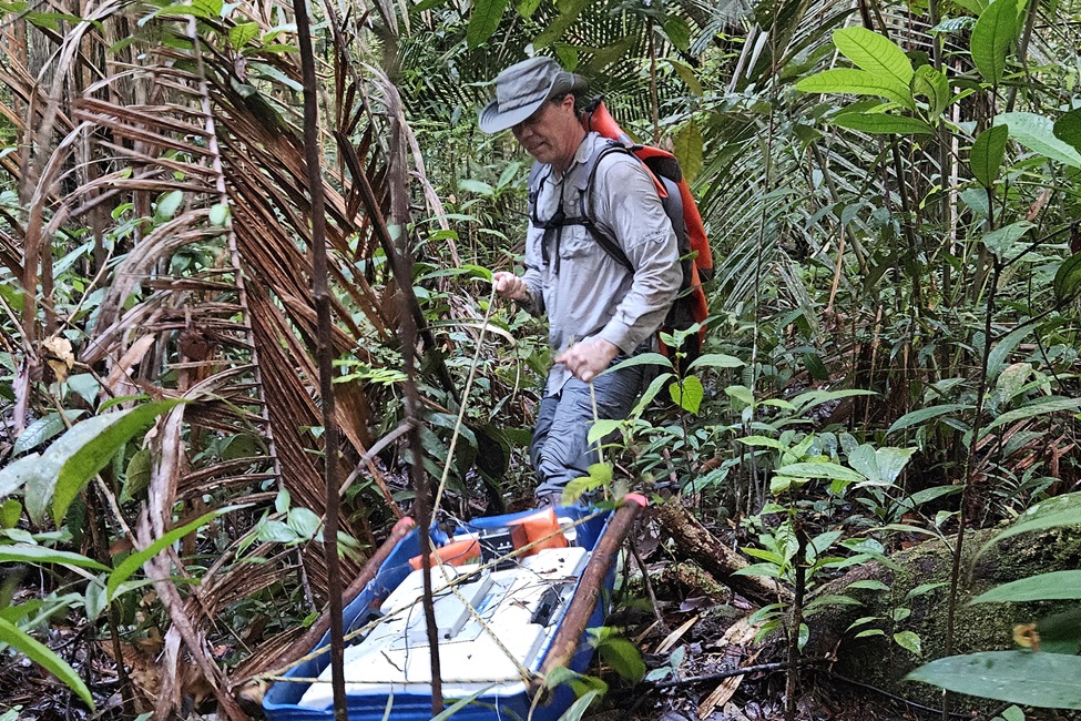
“Our project is designed to enhance our understanding of peat accumulation and gas distribution within the soil, particularly methane, by efficiently acquiring spatially rich datasets using novel geophysical approaches that includes deployment using drones,” said Xavier Comas, Ph.D., main principal investigator and a professor, FAU Department of Geosciences. “We will combine geophysical methods with direct soil and gas samples to explore the influence of factors such as soil physical properties, or gas composition and age, in regulating gas distribution and emissions. This understanding may help reduce uncertainty in overall gas flux estimates from peatlands in support of climate models.”
Additionally, the project will examine how specific environmental factors, such as the presence of permafrost or extreme weather events, affect the distribution and release of gases in these ecosystems. These peatlands will be selected across a range of latitudes, from Alaska to Florida, including sites in Maine and Minnesota.
“Our approach goes beyond traditional methods, such as drilling into the soil to collect core samples or estimating peat thickness based on surface elevation, and includes the use of drones,” said Comas. “Our methods will offer a better picture of how much carbon is stored and how gases are distributed, by improving on data collection efficiency that will allow for larger scale datasets and surveying in areas with challenging accessibility.”
Since drone-based GPR is still a relatively new technology, especially for carbon studies, this project also will help clarify how to best use this technology. The team will create clear guidelines that explain its limitations, challenges, and how to operate it effectively. This will make the technology more accessible to people who aren’t experts in the field, and it will contribute to the development of best practices within the Near-Surface Geophysics Inter-Society Committee, a group focused on advancing geophysical methods.
The research will take place at several field sites that are part of large federal research networks, including U.S. Forest Service experimental forests, the National Science Foundation’s long-term ecosystem research program (LTER), and the AmeriFlux monitoring network.
In addition to studying gas emissions, the research team will use their geophysical data to test a new model for understanding the development of raised bogs, which are a type of peatland. This model will help identify which areas of these bogs are most vulnerable to losing carbon (meaning the carbon can be easily drained away) versus areas that are safe from such loss, which will provide valuable information on how to better protect carbon stocks in these ecosystems.
“This project will significantly advance our understanding of ecosystem carbon management and provide a foundation for future research and action across the globe,” said Valery Forbes, Ph.D., dean, Charles E. Schmidt College of Science. “The development of practical guidelines for new technologies by Dr. Comas and collaborators empowers the scientific community to improve monitoring efforts worldwide. The results will have far reaching implications for climate policy, land use, and environmental conservation, particularly as we address the challenges posed from extreme weather events.”
This piece was originally published at https://www.fau.edu/newsdesk/articles/peatlands-grant-announcement.php. Banner photo: An open pool area in a northern peatland near Grand Lake Stream in Maine. (Photo Credit: Xavier Comas, Ph.D., FAU).
Sign up for The Invading Sea newsletter by visiting here. To support The Invading Sea, click here to make a donation. If you are interested in submitting an opinion piece to The Invading Sea, email Editor Nathan Crabbe at ncrabbe@fau.edu.