By Christine Wiedinmyer and Kari Bowen, University of Colorado Boulder
When a hurricane or tornado starts to form, your local weather forecasters can quickly pull up maps tracking its movement and showing where it’s headed. But have you ever wondered where they get all that information?
The forecasts can seem effortless, but behind the scenes, a vast network of satellites, airplanes, radar, computer models and weather analysts are providing access to the latest data – and warnings when necessary. This data comes from analysts at the National Oceanic and Atmospheric Administration, known as NOAA, and its National Weather Service.
Atmospheric scientists Christine Wiedinmyer and Kari Bowen, who is a former National Weather Service forecaster, explained NOAA’s central role in most U.S. weather forecasts.
When people see a weather report on TV, what went on at NOAA to make that forecast possible?
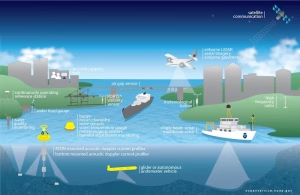
A lot of the weather information Americans rely on starts with real-time data collected by NOAA satellites, airplanes, weather balloons, radar and maritime buoys, as well as weather stations around the world.
All of that information goes into the agency’s computers, which process the data to begin defining what’s going on in different parts of the atmosphere.
NOAA forecasters use computer models that simulate physics and the behavior of the atmosphere, along with their own experience and local knowledge, to start to paint a picture of the weather – what’s coming in a few minutes or hours or days. They also use that data to project seasonal conditions out over weeks or months.
When severe weather is on the way, the agency issues the official alerts you’ll see in the news and on your phone.
All of this analysis happens before the information reaches private weather apps and TV stations.
No matter who you are, you can freely access that data and the analyses. In fact, a large number of private companies use NOAA data to create fancy maps and other weather products that they sell.
It would be extremely difficult to do all of that without NOAA.
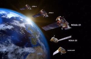
The agency operates a fleet of 18 satellites that are packed with instruments dedicated to observing weather phenomena essential to predicting the weather, from how hot the land surface is to the water content of the atmosphere. Some are geostationary satellites which sit high above different parts of the U.S. measuring weather conditions 24/7. Others orbit the planet. Many of these are operated as part of partnerships with NASA or the Air Force.
Some private companies are starting to invest in satellites, but it would take an enormous amount of money to replicate the range of instrumentation and coverage that NOAA has in place. Satellites only last so long and take time to build, so NOAA is continually planning for the future, and using its technical expertise to develop new instruments and computer algorithms to interpret the data.
Maritime buoys are another measuring system that would be difficult to replicate. Over 1,300 buoys across oceans around the world measure water temperature, wind and wave height – all of which are essential for coastal warnings, as well as long-term forecasts.
Weather observation has been around a long time. President Ulysses S. Grant created the first national weather service in the War Department in 1870. It became a civilian service in 1880 under the Department of Agriculture and is now in the Commerce Department. The information its scientists and technologists produce is essential for safety and also benefits people and industries in a lot of ways.
Could a private company create forecasts on its own without NOAA data?
It would be difficult for one company to provide comprehensive weather data in a reliable way that is also accessible to the entire public.
Some companies might be able to launch their own satellite, but one satellite only gives you part of the picture. NOAA’s weather observation network has been around for a long time and collects data from points all over the U.S. and the oceans. Without that robust data, computer models and the broad network of forecasters and developers, forecasting also becomes less reliable.
Analyzing that data is also complex. You’re not going to be able to take satellite data, run a model on a standard laptop and suddenly have a forecast.
And there’s a question of whether a private company would want to take on the legal risk of being responsible for the nation’s forecasts and severe weather warnings.
NOAA is taxpayer-funded, so it is a public good – its services provide safety and security for everyone, not just those who can pay for it.
If weather data was only available at a price, one town might be able to afford the weather information necessary to protect its residents, while a smaller town or a rural area across the state might not. If you’re in a tornado-prone area or coastal zone, that information can be the difference between life or death.
Is climate data and research into the changing climate important for forecasts?
The Earth’s systems – its land, water and the atmosphere – are changing, and we have to be able to assess how those changes will impact weather tomorrow, in two weeks and far into the future.
Rising global temperatures affect weather patterns. Dryness can fuel wildfires. Forecasts have to take the changing climate into account to be accurate, no matter who is creating the forecast.
Drought is an example. The dryness of the Earth controls how much water gets exchanged with the atmosphere to form clouds and rainfall. To have an accurate weather prediction, we need to know how dry things are at the surface and how that has changed over time. That requires long-term climate information.
NOAA doesn’t do all of this by itself – who else is involved?
NOAA partners with private sector, academia, nonprofits and many others around the world to ensure that everyone has the best information to produce the most robust weather forecasts. Private weather companies and media also play important roles in getting those forecasts and alerts out more widely to the public.
A lot of businesses rely on accuracy from NOAA’s weather data and forecasts: aviation, energy companies, insurance, even modern tractors’ precision farming equipment. The agency’s long-range forecasts are essential for managing state reservoirs to ensure enough water is saved and to avoid flooding.
The government agency can be held accountable in a way private businesses are not because it answers to Congress. So, the data is trustworthy, accessible and developed with the goal to protect public safety and property for everyone. Could the same be said if only for-profit companies were producing that data?![]()
Christine Wiedinmyer is associate director for science at CIRES at the University of Colorado Boulder and Kari Bowen is atmospheric scientist program manager at CIRES at the University of Colorado Boulder.
This article is republished from The Conversation under a Creative Commons license. Read the original article. Banner photo: Satellite data shows Hurricane Milton on Oct. 8 as it moves across Gulf (NOAA).
Sign up for The Invading Sea newsletter by visiting here. To support The Invading Sea, click here to make a donation. If you are interested in submitting an opinion piece to The Invading Sea, email Editor Nathan Crabbe at ncrabbe@fau.edu.