By Robert C. Jones Jr., University of Miami News
Braving winds well over 150 miles an hour in some instances, a group of scientists flew into the heart of the 2024 Atlantic hurricane season’s most destructive storms.
Some of those flights — 67 in all — lasted as long as eight hours, or about the time it takes to fly from Miami to São Paulo, Brazil.
“Without question, it was an unusual number of missions into very intense hurricanes,” said Kathryn Sellwood, a senior research associate at the University of Miami’s Cooperative Institute for Marine and Atmospheric Studies (CIMAS).
Sellwood is part of a select group of CIMAS scientists who played instrumental roles on a multitude of National Oceanic and Atmospheric Administration (NOAA) Hurricane Hunter flights this year, measuring wind speed, barometric pressure, and other conditions that helped forecasters track record-setting storms like Beryl, Helene, and Milton.
Now, with the season officially over, those scientists are poring over a wealth of information gleaned from a new class of drones and mini weather stations that will improve hurricane modeling and aid researchers in learning more about the structure of storms, according to scientist Jason Dunion, who directs the Hurricane Field Program, a collaboration between CIMAS and the Hurricane Research Division out of NOAA’s Atlantic Oceanographic and Meteorological Laboratory.

During flights into hurricanes Ernesto, Francine, Helene, and Milton, Dunion and his team successfully deployed 17 Black Swift SØ drones that collected data from the lowest parts of those storms — just above the ocean surface where the crewed P-3 Orion Hurricane Hunters, affectionately nicknamed Miss Piggy and Kermit, don’t fly.
“One drone flight lasted nearly two hours and another operated at an extreme range of 190 miles from our aircraft after it was deployed,” Dunion said. “One drone recorded an extreme hurricane wind speed of 240 miles per hour just a few hundred feet above the ocean surface.”
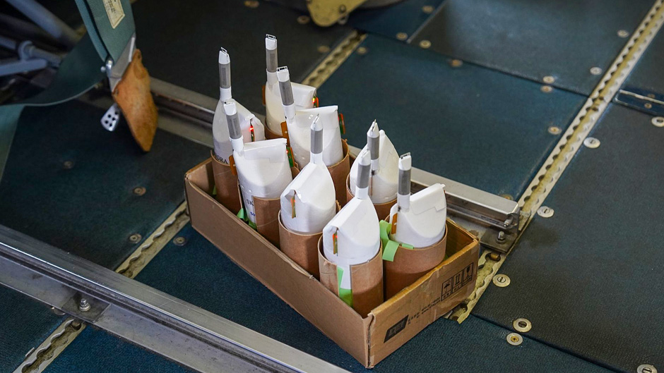
During a flight into Hurricane Rafael, the team deployed the latest tool in NOAA’s hurricane research toolbox: StreamSonde, a new type of storm observation instrument developed by the Finland-based company Skyfora. Like dropsondes, the devices are released from the bottom of the P-3 aircraft, collecting atmospheric measurements as they fall through the storm. But weighing just 14 grams, StreamSondes descend at speeds of only 5 meters per second without a parachute, extending the data collection window for researchers to collect much more detailed data.
“We successfully deployed a swarm of 20 StreamSondes in Rafael’s eyewall, where the strongest winds were found, and this offseason, we’ll examine that high-resolution data to better understand the winds and structure of that storm’s inner core,” Dunion said.
The season proved challenging for the scientists of CIMAS, which is based at the Rosenstiel School of Marine, Atmospheric, and Earth Science. While they flew several of their missions out of NOAA’s aircraft operations center in Lakeland, Fla., the position of some hurricanes required the team to fly some missions out of locations such as Barbados, St. Croix, North Carolina, Alabama, Texas, and even Hawaii, Dunion noted.
Sellwood flew on 14 missions into hurricanes Beryl, Helene and Milton and provided ground support for six others during Ernesto, Debby, Francine, and Rafael. She served as a dropsonde scientist during Beryl, using special software to quality control storm data and ensure its rapid transmission from the aircraft to the National Hurricane Center in Miami, where forecasters looked over the information in near real time.
She trained as a lead project scientist (LPS) on flights into Milton, adjusting flight patterns and monitoring radar data to help ensure the science objectives of the missions were accomplished. “I had my first experience as the sole LPS on the final landfall mission,” she recalled. “It was a difficult flight due to the earlier-than-expected landfall and interaction between the hurricane and an upper tropospheric trough or cold front to the north that spawned multiple tornadoes. Fortunately, we were able to rework the flight pattern, conduct a safe mission, and accomplish our science goals.”
The team, according to Dunion, is already making plans for future Hurricane Hunter missions.
This piece was originally published at https://news.miami.edu/stories/2024/12/hurricane-hunters-test-new-technology.html. Banner image: Hurricane Milton, a Category 5 storm at the time of this photograph, is pictured in the Gulf of Mexico off the coast of Yucatan Peninsula from the International Space Station as it orbited 257 miles above on Oct. 8. (NASA, via flickr).
Sign up for The Invading Sea newsletter by visiting here. To support The Invading Sea, click here to make a donation. If you are interested in submitting an opinion piece to The Invading Sea, email Editor Nathan Crabbe at ncrabbe@fau.edu.


