By Pedro DiNezio, University of Colorado Boulder
One of the big contributors to the record-breaking global temperatures over the past year – El Niño – is nearly gone, and its opposite, La Niña, is on the way.
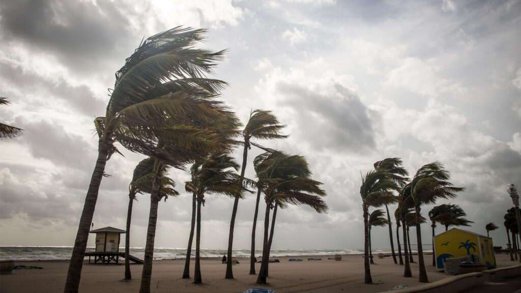
Whether that’s a relief or not depends in part on where you live. Above-normal temperatures are still forecast across the U.S. in summer 2024. And if you live along the U.S. Atlantic or Gulf coasts, La Niña can contribute to the worst possible combination of climate conditions for fueling hurricanes.
Pedro DiNezio, an atmosphere and ocean scientist at the University of Colorado who studies El Niño and La Niña, explains why and what’s ahead.
What is La Niña?
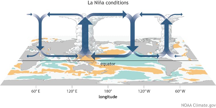
La Niña and El Niño are the two extremes of a recurring climate pattern that can affect weather around the world.
Forecasters know La Niña has arrived when temperatures in the eastern Pacific Ocean along the equator west of South America cool by at least half a degree Celsius (0.9 Fahrenheit) below normal. During El Niño, the same region warms instead.
The tropics have an atmospheric circulation pattern called the Walker Circulation, named after Sir Gilbert Walker, an English physicist in the early 20th century. The Walker Circulation is basically giant loops of air rising and descending in different parts of the tropics.
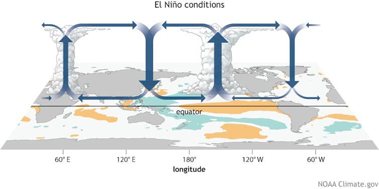
Normally, air rises over the Amazon and Indonesia because moisture from the tropical forests makes the air more buoyant there, and it comes down in East Africa and the eastern Pacific. During La Niña, those loops intensify, generating stormier conditions where they rise and drier conditions where they descend. During El Niño, ocean heat in the eastern Pacific instead shifts those loops, so the eastern Pacific gets stormier.
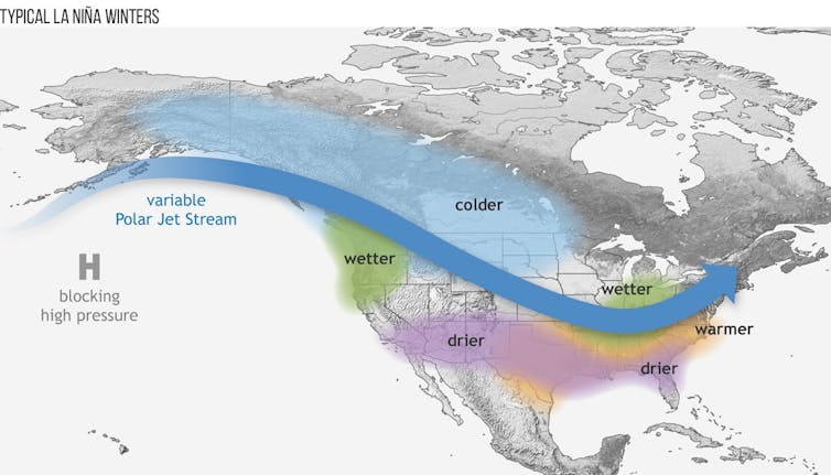
EL Niño and La Niña also affect the jet stream, a strong current of air that blows from west to east across the U.S. and other mid-latitude regions.
During El Niño, the jet stream tends to push storms toward the subtropics, making these typically dry areas wetter. Conversely, mid-latitude regions that normally would get the storms become drier because storms shift away.
This year, forecasters expect a fast transition to La Niña – likely by late summer. After a strong El Niño, like the world saw in late 2023 and early 2024, conditions tend to swing fairly quickly to La Niña. How long it will stick around is an open question. This cycle tends to swing from extreme to extreme every three to seven years on average, but while El Niños tend to be short-lived, La Niñas can last two years or longer.
How does La Niña affect hurricanes?
Temperatures in the tropical Pacific also control wind shear over large parts of the Atlantic Ocean.
Wind shear is a difference in wind speeds at different heights or direction. Hurricanes have a harder time holding their column structure during strong wind shear because stronger winds higher up push the column apart.
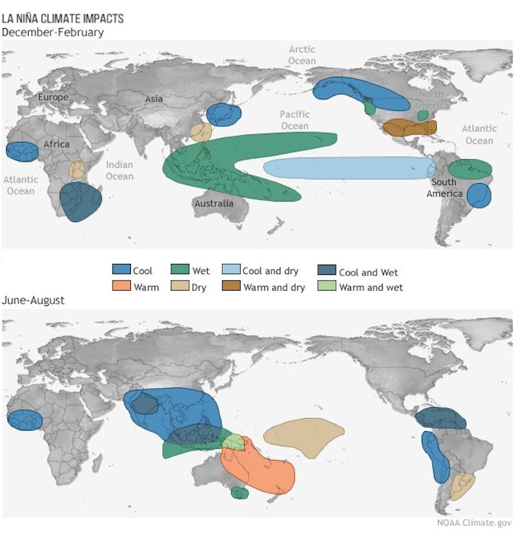
La Niña produces less wind shear, removing a brake on hurricanes. That’s not good news for people living in hurricane-prone regions like Florida. In 2020, during the last La Niña, the Atlantic saw a record 30 tropical storms and 14 hurricanes, and 2021 had 21 tropical storms and seven hurricanes.
Forecasters are already warning that this year’s Atlantic storm season could rival 2021, due in large part to La Niña. The tropical Atlantic has also been exceptionally warm, with sea surface temperature-breaking records for over a year. That warmth affects the atmosphere, causing more atmospheric motion over the Atlantic, fueling hurricanes.
Does La Niña mean drought returns to the US Southwest?
The U.S. Southwest’s water supplies will probably be OK for the first year of La Niña because of all the rain over the past winter. But the second year tends to become problematic. A third year, as the region saw in 2022, can lead to severe water shortages.
Drier conditions also fuel more extreme fire seasons in the West, particularly in the fall, when the winds pick up.
What happens in the Southern Hemisphere during La Niña?
The impacts of El Niño and La Niña are almost a mirror image in the Southern Hemisphere.
Chile and Argentina tend to get drought during La Niña, while the same phase leads to more rain in the Amazon. Australia had severe flooding during the last La Niña. La Niña also favors the Indian monsoon, meaning above-average rainfall. The effects aren’t immediate, however. In South Asia, for example, the changes tend to show up a few months after La Niña has officially appeared.
La Niña is quite bad for eastern Africa, where vulnerable communities are already in a long-term drought.
Is climate change affecting La Niña’s impact?
El Niño and La Niña are now happening on top of the effects of global warming. That can exacerbate temperatures, as the world saw in 2023, and precipitation can go off the charts.
Since summer 2023, the world has had 10 straight months of record-breaking global temperatures. A lot of that warmth is coming from the oceans, which are still at record-high temperatures.
La Niña should cool things a bit, but greenhouse gas emissions that drive global warming are still rising in the background. So while fluctuations between El Niño and La Niña can cause short-term temperature swings, the overall trend is toward a warming world.
Pedro DiNezio is an associate professor of atmospheric and ocean sciences at the University of Colorado Boulder.
This article is republished from The Conversation under a Creative Commons license. Read the original article.
Sign up for The Invading Sea newsletter by visiting here. If you are interested in submitting an opinion piece to The Invading Sea, email Editor Nathan Crabbe at ncrabbe@fau.edu.

